The maps in Marble Springsreflect the places where people carved their memory onto the landscape.
In this demonstration version, click on the name below the map that corresponds to one of the dark boxes on the map.
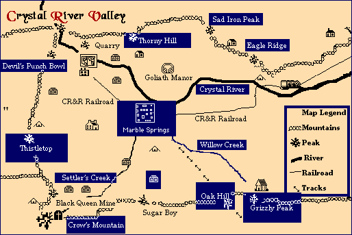
Sad Iron Peak | Thorny Hill | Eagle Ridge | Devil's Punch Bowl | Crystal River | Marble Springs | Thistletop | Willow Creek | Settler's Creek | The Small House | Oak Hill | Grizzly Peak | Crow's Mountain


Crystal River Valley:
Crystal River Valley measures time through memory.
Sad Iron Peak:
14,284 feet. The Stokes' train set up a mining operation here.
Thorny Hill:
7,354 feet. The Grimes' Mine is here.
Eagle Ridge:
12,456 feet. Chirpy stashed her treasures in caves on this ridge.
Devil's Punch Bowl:
The Devil's Punch Bowl is formed by three mountains: Hell's Rim, 11,390 feet; Mount Greer, 13,436 feet; and Silver Hill, 12,890 feet. These mountains have steep cliff sides that form a bowl and hold large deposits of marble. Griffith found these deposits and sold the claim to T.M. Davidson in 1870.
Crystal River:
The main river through Crystal River Valley. Known for its trout and singing rapids.
Thistletop:
13,339 feet. Ute burial grounds. High red and white sand cliffs. Red Birch committed suicide here.
Willow Creek:
Clancy Gaylor was found here with twenty-nine axe wounds.
Settler's Creek:
A small tributary to Crystal River. Katy plays here.
Oak Hill:
10,257 feet. The Washerwoman has a cave here.
Grizzly Peak:
13,339 feet. Best source for chokecherries and rosehips.
Grizzly caught Susannah here.
Return to the beginning of the Marble Springs demonstration.